The Republic of Armenia, which occupies the part of Armenian Volcanic Plateau is situated between the Black and Caspian seas, has the area 28,5 thousand square kilometer. Volcanic deposits occupy about 40% of the area of the republic [26],[27].
In the Republic of Armenia , the region of basalt lavas spreading occupies the North of the republic. Lori table-lend forms the part of it [28]. The length of Lori table-lend is 30 km, the width is 18 km [29]. It extends in the direction from the North - West to the South - East. It has the South - East weak inclination, 1300 - 1600 m height. It is covered by bazalts, andezitabazalts, fluvioglatsial and proluvial sediments of Pliocene and Antropogen. The average capacity of lave layers forms 200 - 220 m.
Caves are allocated in the canyons of the Dzoraget river and its tributaries which cut the Eastern part of the plateau [20] ( Figure 28 ).

Figure 28.The Dzoraget river canyon.
In those canyons there are initial volcanic caves ( gas bubble - caves ), which appeared in the process of lava formation as well as secondary volcanic caves.
Secondary volcanic caves nearly completely consist of the caves, originated as the result of water influence, and the caves originated at places of easily weather slags, which are met in the lava. Secondary volcanic caves of other types, how for example, the caves of cracking lavas at the time of tectonic and gravital movements, the cave formed at places of dumping of volcanic separate parts, the caves between lavas and landslides and others [30],[31] are absent.
In order to have possibility to give the subject, presented in this article in blief look, the Dzoraget canyon was devided into six agreed parts ( a, b, c, d, e, f ) (Figure 29).

Figure 29. Caves allocation in six sections of the Dzoraget river ( a, b, c, d, e, f )1 - the buble-cave, 2 - the caves formed of volcanic slags, 3 - the caves digged by water.
In the Figure 30a all the caves of a b, c, d and e sections are jointly summarized. The caves of f section are not given in the Figure 30 as there is no place in it. In the Figure 30 abscissa axis represents the Dzoraget canyon. The arrows placed perpendicularly to it mean correspondingly the tributaries of Dzoraget: 1- Tashradgur river, 2 - Chknagh river, 3 - Miskhana river, 4 - Agarak Small water, 5 -Agarak Big water, 6- Yaghdan Small water.
The caves are the perpendicular lines from the crack of abscissa. Gas bubbles are marked by point row (...), the caves formed in the slag are marked by solid lines ( ---- ), the caves digged by water are marked by foltering lines ( - - - ). The length of the lines corresponds to the hardness of the caves. The total number of the caves is 324.
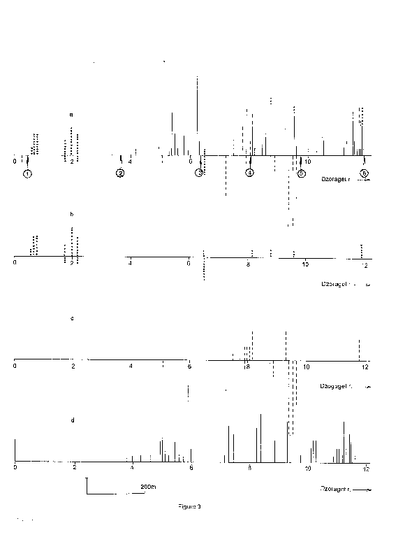
Figure 30. The caves of the Dzoraget river a, b, c, d and e sections. The perpendicular line is given in the left corner it is the scale and it corresponds to two caves. a - the total number of the caves, b - the bubble-caves (.....c - the caves digged by water ( - - - ), d - the caves formed of volcanic slags (----).
As it is seen from the Figure 30a, the big part of the caves is allocated in the left bank of Dzoraget, in the rock which look at the South.
In the Figure 30b gas bubble - caves ( the primary caves ) are represented. They are more on the left bank of the river than on its right one.
In the Figure 30c those caves are represented, which are obliged to water for their existence. The number of those caves is great on the right bank.
Subtracting the caves formed under the influence of water from the total number of the caves and the bubble-caves, we get the number of " slag " caves (Figure 30d ). It turns out that there is no even one cave of that type on the right bank of the Dzoraget river.
The canyons, in the rocks of which the caves are allocated, have marked direction. The main canyon, which is the canyon of the Dzoraget river, extends in the direction of the East - West. The canyon of the Chknagh river, which joins it from the South, has the same one. The rest canyons have the North - South direction. So, the caves of the researched area have strict orientation regarding the parts of the world.
The total length of the rocks which look at the South forms 22 km. The number of the caves formed in them is 225.
The rocks, which look at the North form the right side wall of the main canyon. The total length of these rocks is 21 km, the number of the caves containing in them is 48.
The total length of the rocks which look at the East is 3 km, the number of the caves is 67.
The total length of the rocks which look at the West is 0,8 km, the total number of the caves is 8.
In Table the dependence of the total number of the caves on the position which they have regarding the parts of the world is given.
Table 11
|
The orientation of the rocks regarding the parts of the world. |
The total length of the rocks ( m ). |
The total number of the caves |
The number of the caves which is for one km. |
|
the East |
3 |
67 |
22,3 |
|
the West |
0,8 |
8 |
10 |
|
the South |
22 |
225 |
10,2 |
|
the North |
21 |
48 |
2,3 |
As it is seen from the table, the rocks which look at the East contain the greatest number of the caves in one km ( 22,3 ). In the rocks, which look at the West and the South, the number of the caves in one km is approximately the same, correspondingly, 10 and 10,2. The number of the caves originating in the Northern rocks is considerably small, only 2,3 in the distance of 1 km.
The table gives the opportunity to estimate those factors, which influence the speed of the cave origin of the secondary type originating in the rocks. Among the caves brought in the table only the rocks, which have the Northern orientation which are not subjected to the direct influence of the Suns rays. The result is obvious 2,3 (North) and 22,3 (East) on the same value of the cave area ( in one km ).
Can the Suns rays really accelerate ten times the phenomenon of cave origin? In order to answer that question it is necessary to come back to the phenomenon of the temperature dependence of the chemical reaction speed, because the intensification of the rocks chemical weather takes place under the immediate influence of the Suns rays. According to the temperature dependence of the chemical reaction, raising the temperature of the reaction in 10O the speed of the reaction increases from 2 to 4 times [22]. So:
g = KT+5 : KT-5 » 2 ¸ 4 ( 1 ).
Here K is the constant of the reaction speed, and g is the temperature ratio of the reaction.
The temperature dependence of the reaction speed is generally determined by the following formula:
K = KO.exp(-E/RT) ( 2 ).
E is the energy of the reaction activation, KO is pre-exponential multiplier. According to the expressions ( 1 ) and ( 2 ) in order the origin speed of the caves in the East rocks to surpass the origin speed of the caves in the Northern rocks 10 time, the temperature of the Eastern rocks must always be 20 - 30O higher than the temperature of the Northern rocks.
Is the temperature regime really so? The total period of time ( t ) of the cave origin consists of the rotation of nights and days. In the nights the difference of the rocks temperature reaches the least and the same temperature is firmly established everywhere. So, the half t/2 of the period of time must be neglected. t/2 ( days ) are left. The number of rainy and foggy days is subtracted when the same temperature is firmly established everywhere. For that region it forms ~ 90 days or 25% of the daytimes. It is subtracted from t/2:
t/2 - ( t/2 : 4 ) = 3t/8.
Of the rocks D T = TEastern - TNorthern = 20 - 30O the difference cant be remained in the second part of the day also, when the Sun begins to heat first the rocks looking at the South and afterwards the rocks looking at the West. Hence 3t/8 period of time is also devided : 3t/8 : 2 » 0,2t.
So only in the process of ~0,2 part of the whole part of time of the caves origin can be observed as such temperature regime, when in the Eastern rocks the chemical weather under the immediate influence of the Suns rays speeds up 10 times.
On the base of the statements and ( 1 ) and ( 2 ) formulas mentioned above the thermal influence of the Suns rays in the Eastern rocks can increase the number of the cave mostly up to two times and make it 5 in the distance of 1 km.
The rocks looking at the South get more warm than the rocks looking at the East or at the West. Nevertheless, despite of it, as the table shows the caves in the rocks looking at the East exceed. It means that there is a factor forming the caves, which is stronger than the thermal influence of the Suns rays. Not getting deeper into the mechanism of the phenomenon, it is possible to estimate the quantity value of the phenomenon. The research of the caves way in gives the opportunity of it. Some caves are given in the Figure 31, which look at the South. Their parts indicated by the arrow are directed in the direction of the East. There are also " bubbles" caves and " lens " cave.

Figure 31. The total scene of bubble-caves weather. The walls of the caves looking at the East are indicated by the arrow.
In both cases, if the cave isnt weathered, the walls preserve their initial look well. In one case it is the freezing lava with the bend of the capsule special to the spherical mass of the fluid, in the other case it is the uneven surface of the melt lava interacting with a great lump.
The Western section of the all caves ways in given in the Figure 31, are of the some look mentioned above. It means that those walls are weathered mostly with several millimeter depth, otherwise the stone surface had to loose the typical look of the freezing lava.
The state of the section looking at the East is different. As it is seen from the Figure 31 the walls looking at the East had weathered up to ~50cm depth. Hence, the speeds of the weather of both walls ( VEastern and VWestern ) correlation forms:
VEastern : VWestern » 50 : 0,1 » 500.
Independently from the mechanism of the weather, the cave increases as the result of the weather ( Figure 32 ). For clarity, the cave which has the spherical look is taken.

Figure 32. The total scene of the cave weather: a - ideal case, b - real case.
In any period of time the value of the cave, which has the look of the half-bubble, is determined by the following formula:
V =[4p (r +D r.t)3 : 3] : 2 ( 3 ).
t - is the means of time of weather, D r - is the thickness of the rock layer weathered by the same means of time. In reality, the walls of the cave arent weathered steadily. Section which are more and less weathered form and the cave gradually becomes asymmetrical.
Now lets discuss those caves, the formation of which is connected with the activity of water. Usually, between the separate cycles of the lava eruption eluvio-deluvial, aluvial beds are allocated. Those are red like a brick, burnt hard layers -
"litomarge". Litomarges serve as watertight layers for the lavas, which lie above and they are carrying water and with some crocks. Opening them by the deep erosion by the Dzoraget river canyon, springs knocked out from there. By the influence of water caves are formed.
The caves of that group display the extraordinary stable regularities of the formation. The caves of the Western rock of the Figure 30e serve as the best example. In the Figure 33 the arrangement of those caves in the Dzoraget canyon are given. The caves are devided into five groups due to their allocation ( 1, 2, 3, 4, 5, ).

Figure 33. The groups 1, 2, 3, 4, 5 of the right bank symmetrical caves of the e section of the Dzoraget canyon.
The caves of first group consist of six caves ( No.1 - No.6 ). These are not big caves. The caves of the second group are allocated 10 m towards the East from the first one ( No.7 and No.8 ).
From the second group to the third one there are no caves in the distance of 50m. The third group consists of seven caves ( No.9 - No.15 ). The ceiling of cave No.10 of this group is situated on the level of the neighboring No.9 cave bottom. Waters, which flow from the bottom of No.9 cave and flow out from the ceiling of No.10 cave, digged it. The cave No.11 of the same group is the most famous cave of the Dzoraget canyon with its beauty and height ( h » 15 m ). On the western wall of the cave there is the cave - crevice of the secondary origin with 3,5 ´ 1,5 ´ 3 m 3 sizes ( as the cave No. 10 ). The cave No. 13 is being formed now, It is a cave - carnice, its all sides are open. Water flows from the back wall. The cave No.14 is just on the level of the river, the waves of the river enter the cave. The cave No.15 is also on the level of the river.
The forth group of the caves is separated from the third one only by six meters. It consists of six caves (No.16 - No. 21 ). The cave No.16 is being formed just now. The cave No.19 is the cave of the secondary origin.
The caves of the fifth group are 10 meters far from the cave of the fourth one. This group has five caves (No.22 - No.26 ).
There are the remains of the ancient big caves to the East from the fifth group. There are also caves of the secondary origin. The shore rock which is more towards the East is finished.
The arrangement of the caves of all five groups is given consecutively in Figure 34a. As it was mentioned above No.3, No.10 and No.19 caves have the secondary origin. Separating those three caves, the rest 23 caves display rather stable periodicity of the allocation ( Figure 34b ). The distance between the caves equals to 8 - 10 meters in average. There, where the distance between the caves is great, the ancient caves were situated, which were destroyed because of decomposition and weather.

Figure 34. The arrangement of the symmetrical caves of the Dzoraget canyon e section. a - the total number of the caves, b - the arrangement of the caves without No. 3, No. 10 and No. 19 caves. The vertical line in the left corner of the Figure is the vertical scale, which equals 50 meters.
Not only the arrangement of the caves is subjected to the law but such kinetic parameters as the height of the caves -h ( Figure 35 ), the width -a ( Figure 36 ), the depth - I ( Figure 37 ) and the volume - V ( Figure 38 ).

Figure 35. The regularity of the change of symmetrical caves height ( h, meter ) of the Dzoraget canyon e section.

Figure 36. The regularity of the change of symmetrical caves width ( a, meter ) of the Dzoraget canyon e section.

Figure 37. The regularity of the change of symmetrical caves depth ( I, meter ) of the Dzoraget canyon e section.
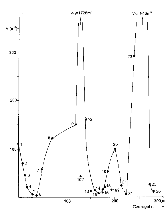
Figure 38. The regularity of the change of symmetrical caves volume ( V, meter3 ) of the Dzoraget canyon e section.
The height, the width and the volume of the caves are subjected to changes by some regularity: they grow, reach the maximum value for the cave No. 11 then they decrease showing not essential medium peaks. They reach the maximum in the case of the cave No.24 for the second time. Then kinetic parameters, continuing to preserve the regularity of the change, decrease.
Of course, the most important parameter among those four ( l, a, h, V ) is the volume of the cave. It represents itself the product of those previous three and express the kinetic regularity of the cave formation more completely.
The regularities, which were described, arent exceptions. The kinetic regularities, displayed by the caves originated under the water influence in the volcanic rocks on the same bank of the river are repeated 700m to the East from the place of confluence of the Miskhana river and Dzoraget ( Figure 39 )and ~200m to the West from the path of the Gjulagarak village ( Figure 40 ).

Figure 39. The change of the kinetic parameters of the symmetrical caves situated 700 m. to the East from the place of confluence of Dzoraget and Miskhana rivers on the right bank of the Dzoraget canyon c section. 1 - depth ( I ), 2 - height ( h ), 3 - volume ( v ).
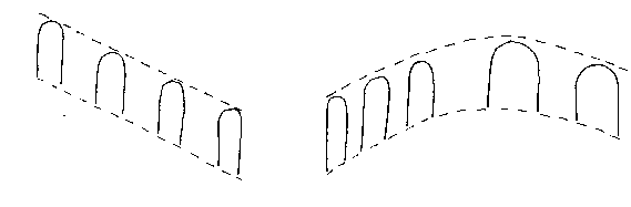
Figure 40. On the right bank of the Dzoraget canyon d section, the total scene of symmetric caves situated 200 m. to the West from the path of Giulagarak.
The same regularity is observed on the left bank, 200m to the East from the path of the Gjulagarag village( Figure 41 a, b ). We can see the regular form of the volume of the kinetic parameter distribution of the caves. The second cave is allocated 50m to the West from right side Eastern first cave. Three more caves are situated more to the West. In two big caves of those water flows, and the third one has the secondary origin. It is far small of the rest caves by its sizes.
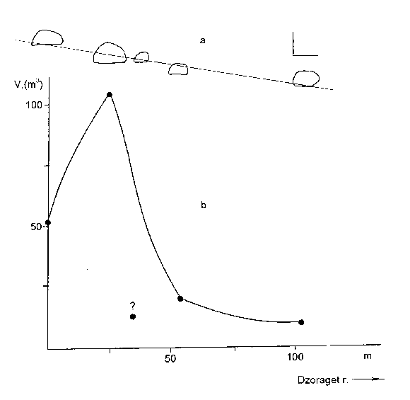
Figure 41. On the left bank of the Dzoraget canyon d section, the symmetrical caves situated 200 m. to the east from the path of Giulagarak: a - the arrangement of the caves, b - the regularity of the change of the caves volume. In the right corner of a Figure are the scales of abscissa and ordinate ( each 10 meters ).
The symmetrical arrangement of the caves originating under the influence of water is obviously determined by the symmetrical cracks existing in the rocks [32]. The rocks have horizontal and perpendicular cracks. Water, which is absorbed in the rocks as a result of atmosphere precipitations flows through the biggest one. Water digs the cave. Part of water flows out of the cave, the other one is absorbed into the bottom. That absorbed water also forms the cave but a smaller one and it is repeated so. So the "water" caves are as small as the level, where they are situated, is low.
Figure 29 shows, that the volcanic caves appear mainly in groups. Their biggest part originated in the slags. In order to understand the mechanism formation of this kind of caves, it is necessary to know the distribution of the slag substance in the rock of the canyon. It is possible, while researching the transverse section of the rock blocks. The best example of that kind of section is the canyon of Agarak Big Water. It is perpendicular to the Dzoraget canyon and has approximately 1,5 km length ( Figure 29d ). As it is seen from Figure 29d, the number of the caves increases while moving through Big Water canyon to the South. The phenomenon would be explained with difficulty, if there wasnt one circumstance: while approaching the main canyon, Big Water canyon becomes deeper, At the same time with deepening of the canyon the hardness of the caves on the unit length becomes more. The growth of the number of the caves with deepening of the canyon is represented in the Figure 42.
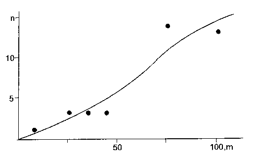
Figure 42. Increase of the number of the caves with deepening of Agarak Big Water canyon.
If we shade the rock layer containing the caves, as it is done in the Figure 43, the section of the horizontal and perpendicular layers will give the distribution of the points able to form the cave in the block.
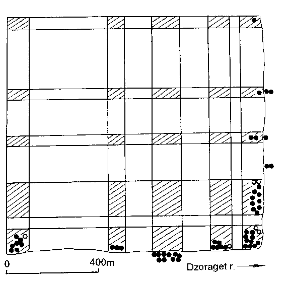
Figure 43. The allocation of the points able to form caves and caves in the block of Dzoraget - Big Water section ( shaded parts ).
It isnt difficult to imagine what happened: ,,embryos" easily weathered slag masses of the future caves allocated on the lava surface during the eruption of the volcano. Things throwing and running out to the sky during the eruption fell down in the flow of the running lava [33]. Lava takes the next wave of the thrown things ( slag, pieces stone, pumice... ) away with it. Some time later the next throwing away takes place. The previous products have a already passed a part of way with lava before that. The scene is repeated periodically ( Figure 44 ).
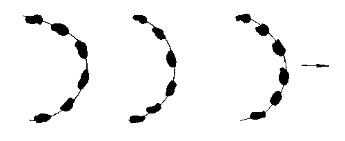
Figure 44. The distribution of great lumps able to separate the cave on the lava flow.
The "slag" caves have rather well expressed medium sizes. In average, the volume of one great lump forms 4 ´ 4 ´ 3 » 50m3 and its weight is 100 ton. (We accept d » 2g/cm3 ). We can estimate that energy, which is thrown away like a ,,bomb" from the crater of the volcano and lifts H meter. Solid, which is on the height of H above the earths surface and have m mass, Have W = m gH potential energy: g - is the speed-up of the free fall, 9,8 m/sek2. In order the solids to reach H height, it is necessary to turn aver to it at least W = mgh value energy. In given case, that energy is turned over to it from the crater.
At the time of magma degasation, the separating gases, being thrown out of the crater have a kind of throwing out strength. Is that strength really enough for ,,shooting" those kind of masses? That strength seems not enough from physical-chemical point of view, because degasation is the phenomenon which demands time and throwing lumps of soil away is an instantaneous phenomenon. The phenomenon is more typical to the reactions of explosure. We`ll discuss in the following title the phenomenon of explosure of the hydrogen - oxygen mixture in the crater at the time of eruption:
2H2+ O2 = 2H2O
It is possible that that difficult for comprehension phenomenon is realized by this reaction, which is throwing huge mass of fragments away during the eruption.